V 1.0.2 vom 16.03.97 zurück zur GPS-Seite
Review of the Garmin 12XL GPS Receiver
by Joe Mehaffey and Jack Yeazel
Revision 7-Mar-97
(rev: Ext Ant, Current Draw, Dead Reckoning, Data Smoothing,++)
I (Joe) recently received a new G-12XL and Jack and I have been
comparing it to my Magellan M-4000 and Jack Yeazel's Garmin G-45
(not the 45XL).
First, a review of features and operation. Most of the features
are the same as the Garmin 45XL unit according to news group
correspondents.
As others have mentioned, the G-12XL does lock on to the SV
signals quickly. From a "cold" start, after a 2000 mile UPS
trip, it locked on in 56 seconds. After a 3 hour off time, the
lock up time was 20 seconds. Specifications are "warm start" ,
15 seconds, "cold start" 45 seconds, "autolocate" 5 minutes.
My Magellan M-4000 took 95 seconds from a "warm" start situation
in the same environment. Jack's G-45 is a bit faster than the M-
4000. A new feature that I have not seen before is the
"Initialize by Country" feature. Apparently, this enhancement
was made on the Garmin 45XL version as well. With this feature,
you may select your country from a list and it will speed up the
Autolocate from an unknown location.
The G-12XL's specification for position accuracy is 100 meters
with SA, 15 meters exclusive of SA and 5 meters with suitable
DGPS correction signals. This is considerably better than the
DGPS specs available with most low cost single and dual channel
multiplexing systems. The DGPS error specification for the
G-45XL for instance is 10 meters. This shows that reduced error
capabilities are achievable with even low cost multichannel
receivers as compared with single and dual channel units. An
averaging mode is available in the G-12XL to improve waypoint
accuracy in the presence of SA. I have observed error estima-
tions in the range of 50ft with a few minutes of averaging at a
spot. We hope someone will test the G-12XL in a controlled
environment and let us hear how accurate the G-12XL's indicated
error measurement readout really is.
The G-12XL operates from 4 AA batteries or from external power in
the range of 10 to 40 volts DC. External current draw is about
120ma (light off) and 150ma (light on). Ten hours is specified
as the AA battery life. We have not tested this parameter. The
data/power cable used is the same as the Garmin G-45 units. The
external antenna connector a miniature MCX coax jack is located
on the rear of the unit just behind the "up arrow" button. A six
inch adapter lead MCX to BNC jack is available for US$20. We
measured 4.35 volts on the connector with battery voltage
measuring 5.05vdc on the G-12XL's test screen. The Garmin GA-26
amplified antenna and the Magellan M-4000 amplified antenna both
work with the G-12XL (with adapter cable). We believe most other
amplified GPS antennas will work as well. The G-12XL apparently
has a diode switch to disable the internal antenna (to prevent
interaction) when the external antenna draws power (unlike the M-
4000).
The unit puts out a variety of NMEA protocols, 0180, 0182, 0183
ver 1.5, and 0183 ver 2.0. Other proprietary sentences are
output as well. DGPS signals in the RTCM-104 format are accept-
ed. A setup screen permits selection of the I/O combination
needed by a particular application.
The G-12XL has a number of features and displays that are useful.
These include:
a) A tape style compass display screen showing direction of
travel, track bearing, speed, trip distance, altitude,
lon/lat position, and time of day. On the 12XL, you must
set in the time offset from UTC manually.
b) A compass type display screen shows direction of travel and
has an arrow pointing to the next waypoint. This screen
also provides the name of the next waypoint, the bearing,
distance, along track speed, speed, cross track error
with reference to the next waypoint. This display can be
alternated with two pushes of the "enter" button with the
highway display below.
c) A highway page type display screen shows off track distance
similar to a CDI display. The CDI scale is adjustable in
units of .25, 1.25, and 5.0 sm, nm, or km. This screen
includes bearing, distance, track over ground speed,
speed over ground, estimated time of arrival, and velocity
made good, all with reference to the next waypoint. The
name of the next waypoint is also displayed. If you get too
far off course, a message is presented telling you the
proper course to steer to get back on course.
d) A moving map display is provided to plot your course over
ground. In addition, bearing, distance, track over
ground, and speed over ground are provided on this same
display. Any waypoints saved in the machine are displayed
on the moving map page as they come within range of the map
scale selected. Note. The "map" is a blank page until you
put in your waypoints. This screen has pan and zoom and
scales from .2 mile to 320 (miles or other units) which
works quite intuitively. You can "point" at a waypoint on
the map and the distance and bearing to that waypoint from
your present position will be displayed. You can also
"mark" and store a new waypoint by moving the cursor to the
desired position on the map and pressing the MARK key plus
ENTER. The map may be north up, or current track up, or
direction of current route segment up. The map display can
contain position range rings, plot straight lines between
waypoints, display "nearest" nine waypoints, or put names
beside waypoints. The map screen also supports zoom and pan
features.
e) A distance and sun screen is provided to compute the dis-
tance between any two waypoints and to display sunrise and
sunset information for your locality.
f) A simulator feature provides display of simulated motion and
simultaneously outputs simulated tracking data to your
computer for test of mapping software, data gathering
simulations and such.
g) A screen backlighting timer permits setting the backlight to
0, 15, 60, 120, and 240 seconds when the unit is on bat-
tery power. The screen will stay on continuously if exter-
nal power is connected and the backlighting is turned on.
The backlighting is uniform and tinted blue and the display
at night is easy to read. The display is clear and appears
to be the same resolution as that on the Garmin G-45.
Screen contrast is also adjustable on the setup screen.
h) You can turn off the warning tone! A screen permits beep on
warning messages, keystrokes and warning messages, or NONE.
i) A message screen page allows you to view system warnings and
messages. These include such things as approaching way-
point, no DGPS position, poor gps coverage, and battery is
low. The total number of such advisory messages is twenty
one.
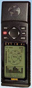
j) A satellite status page comes up when you first turn the
unit on. It displays a "fuel" or battery gauge showing
battery remaining, and a "compass" display of satellite
numbers (1...32) in view along with signal strength bars for
each satellite potentially in view (up to 12). If the unit
is powered from an external source, the "fuel" gauge bar
disappears. The signal strength bars are hollow if the GPS
has found the SV and is not yet locked and changes to solid
black when lock is made to each satellite in turn. Each
signal strength bar is marked with the associated satellite
number. On the polar plot, SV numbers are white on black
when not locked black on white when locked.
k) Waypoints may be named with a six character name.
l) A track log is provided which can log from 0 to 999 points.
If 999 points are selected, the track log actually appears
to record 1024 points and 1024 points are also referenced
during download on the G-12XL's screen. After the maximum
selected number of track log points is recorded, the G-12XL
discards the oldest log points as new are added. The user
can select "automatic" track log which logs whenever
direction or speed changes. Alternatively, one can elect to
log a track point at intervals from every second to up to
every 99 hours as needed by filling in a hhmmss entry in the
track log screen.
m) A track back feature provides the ability to steer you
backwards along your initial outward course without your
having to have entered waypoints manually during your out-
ward transit.
n) The G-12XL accepts the RTCM-104 version 2.0 DGPS correction
format version. The GPS can control the frequency of suit-
ably equipped DGPS receivers when it is set to the RTCM/NONE
mode (No NMEA data output.). DGPS beacon frequency and
signal strength will display on the G-12XL when DGPS activi-
ty is present on the RTCM input.
o) External I/O signal modes available are: NMEA/NMEA,
RTCM/NMEA, GRMN/GRMN, and RTCM/NONE. Alert messages (and
optional beeps) alarm DGPS signal failure when that mode is
enabled.
p) A waypoint proximity alarm can be programmed to alert the
user with an audible "bong" when the selected waypoint is
being approached. Up to 9 proximity waypoints may be used.
q) The user may select a Magnetic heading reference or true
north as required. Other options are grid reference and
User selectable.
r) The G12XL has 107 built in map datums plus the capability
for users to set in their own datum settings.
s) The user may enter his own grid format if desired.
t) If the ENTER key is pressed and held when the unit is turned
ON, an undocumented test screen is activated which
incidentally measures battery voltage.
Subjective Observations of Performance
Jack Yeazel and I have been out testing the 12XL on the road and
in the field. The G-12XL has worked without a flaw that either
of us could find. We uploaded and downloaded waypoints, tracks
and routes using Waypoint+(W95), and G7to..(DOS). We tried it
out on SA4 and Delorme MapExpert, and Vista. No problems found.
We compared it with the G-45 (not an XL) and with our earlier
experiences with the G-45 tested against the M-4000 for lock
times and the ability to hold lock under various situations. In
a sentence, the 12XL outperformed the other two in every test
for lock stability, multipath performance, re-lock after an
underpass, and ability to suddenly change direction without loss
of lock. We were very impressed. We tried the G-12XL (barefoot
[antenna wise]) on the dash with the G-45 with external amplified
antenna mounted to the windshield. Still the G-12XL outperformed
the G-45 in every test. We were very impressed at the speed that
the speed the G-12XL responded to changes in direction as
compared to the other two units. At about 4mph, the 12XL would
complete a change of direction in about 15 feet, the G-45 about
50ft, and the M-4000, about 60ft. The G-12XL laid down smooth
tracks on our highway maps during all tests. No gaps, jumps,
etc., (The G-12XL has data smoothing.) The G-45 had a number of
minor jumps of perhaps a few hundred feet at most in multipath
situations. The M-4000 did the same with a couple of jumps out
to perhaps 800ft but returning within perhaps 30 seconds once
lock was re-established. Note: We were not able to test the
unit under heavy tree cover as it is winter in Atlanta and most
leaves are off our trees. However, a number of correspondents
have told us that the G-12XL is approximately on a par with the
excellent Eagle Explorer receiver performance in a forest
situation.
These are the major features We have observed in playing with the
G-12XL. Our impressions are that the G-12XL is an improved G-
45XL with a much faster acquisition of satellites and a well
thought out user interface. There are a few additional features
that will appeal to many, particularly the improved (12 channel)
receiver performance and quicker lock. The more frequently used
display items are easy to use, but the more obscure require
several screens and menus and half a dozen button pushes to
access. All in all, We like the unit much better than the older
units we have tested. (We did not have an EE to test, but
likely it would track about as well as the G-12XL, but as of now
no data cable or software is available for mapping or
upload/download with the EE to the best of our knowledge.
Unfortunately, it is hard (for us) to dynamically test a GPS
without the use of a moving map display system attached. Without
a map display, many GPS tracking errors can go unnoticed.)
We made these tests using two Toshiba 2150C laptop computers both
running moving map software. The two gps units were operated
simultaneously on the dash in front of the driver (G-12XL) and
with amplified external antenna on the lower part of the
windshield in front of the passenger (G-45). The laptops were
positioned so both displays could be watched simultaneously and
then we drove over a course of perhaps 30 miles and evaluated the
relative performance of the GPS equipment by observations
including the GPS "cookie trails' on the moving map display.
Dropouts of the G-45 for instance would show a break or jump off
the track of the "cookies" for that unit.
More Field Tests (2/1/97): I took the G-12XL into the North
Georgia mountains where I have previously had problems with my M-
4000. The improvement in performance evident in the G-12XL is
substantial. We drove for about 4 hours in twisty mountain roads
with switchbacks and steep mountains on the side of the road.
The M-4000 would frequently lose lock and take up to minutes to
recover. The G-12XL never lost lock as long as it was laid flat
on the dash of the car. The G-12XL produces position output to
the computer much faster than the M-4000. With the M-4000, the
position indicated on the computer map usually follows behind
actual position by 200 to 300 feet making you unsure if the next
road intersection is the one you want. With the G-12XL, points
plotted on the display about every two seconds and seemed to be
only perhaps 50ft behind the actual location at the moment of
plot. Several times, just before we entered a switchback, I
removed the G-12XL from the dash and put my hand across the
antenna to block sigs. Then after the switchback, I put the G-
12XL back on the dash. Within less than 5 seconds, the G-12XL
recovered lock. In similar tests, the M-4000 required up to a
couple of minutes to recover lock. Multi-Channel Parallel GPS
receivers have MY vote! A couple of EE owners have reported that
the EE would work on the seat of the car beside them. I tried
this out with the G-12XL for a short time. Perfect operation did
not occur. However, it did provide a track almost all of the
time, but sometimes, switchbacks would interrupt proper tracking
for 10 to 20 seconds. There were 6 to 8 sats visible while I was
running the "on the seat" test, still.. Not Bad! Actually,
this is superior performance. Also, multipath caused additional
position errors in the range of perhaps 200 feet SOME OF THE TIME
when the G-12XL was located on the seat instead of the dash.
When I put the G-12XL back on the dash, the track would
immediately come back to normal error. Therefore, if you are
interested in accuracy, the dash is the better location. An
outside antenna would be even better. My hat is off to the EE in
this regard as well since it is reported to provide similar
performance. With the Garmin G-12XL, I don't think I will
need to carry my amplified external antenna around anymore.
Operation on an automobile dashboard appears to give 100%
satisfactory operation.
We also noted that both the G-45XL and the G-12XL have a form of
"dead reckoning" for moments when signal dropouts occur. For
instance, if the G-12XL is tracking along and just before a
sharp turn you invert it and block its antenna, it will continue
to track straight for about 30 seconds. It also provides a very
good data smoothing filter to throw out random fixes that are way
off track. This results in an exceptionally smooth track on a
moving map display even when multipath is present. Even with
this filter, there was no overshoot apparent during quick stops,
sharp turns, and similar maneuvers when normal continuous
tracking was taking place.
If anyone has any additions, questions, suggestions, error
corrections other comments, please feel free to Email Jack or
Joe.
Joe Mehaffey and Jack Yeazel
w2jo@bellsouth.net river5@peachnet.campus.mci.net