Satellite navigation — why?
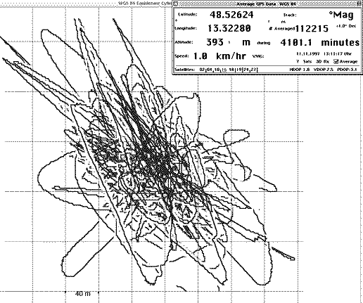
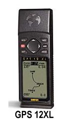
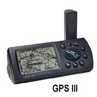
One of my favourite toys is a small handheld GPS device. With one you can do all sorts of great things. Of course it shows the current position, plus heading, speed, atomic time, a mini-map with waypoints and distances to them, and amusing extras such as sunrise and sunset times, and much more. The smallest devices currently available are the Garmin handhelds. I bought a Garmin GPS40 at the end of 1994 from Därr in Munich for almost 1,000 Marks; current prices are of course much lower. In March 1996 came the Garmin GPS38 — a GPS40 without the antenna socket but with more route memory, a compass page and true distance tracking. In January 1997 the Garmin II appeared, offering horizontal and vertical operation; the fold-out antenna seems problematic on a motorcycle to me. Due to water ingress I had already lost two small Garmins, both replaced under warranty. The symptoms are always the same: condensation on the display, possibly failure of pixel rows, but reception itself still working. The hard use on a motorcycle over thousands of kilometres, with vibrations and heavy rain showers, takes its toll — it really should not happen. As a technological breakthrough, Garmin became the first manufacturer to fit its small handhelds with a 12-channel parallel receiver. Instead of constantly switching from satellite to satellite, up to 12 satellites are now tracked simultaneously. This brings dramatically faster position finding and also higher precision in tracking and position calculation — insofar as the artificial degradation by the US Department of Defense (so-called SA) permits. As soon as this new technology was announced I ordered a GPS 12XL, which arrived from the USA after some weeks of production delay. It has the same form factor as the GPS38/40 with its 8-channel multiplex receiver, but with a genuine 12-channel parallel receiver and more memory (512 waypoints, 1024 track points). The receiver is very fast with this parallel-reception technology and even works under light foliage. I am personally satisfied with the reception system and the software. Despite all of Garmin's assurances that the waterproofing had been improved, I did once get a condensed display on my GPS12XL — what will happen next? I sent the device on 03.11.97 to Garmin Europe in England to claim under warranty. Garmin is quite generous about warranty: within just 6 days of posting my GPS12XL to England I received a brand-new GPS12XL with current software. The annoying software speed limit of 90 knots (approximately 167 km/h), which all earlier models had, was finally dropped in the GPS12XL and other newer Garmins. When this speed was exceeded, absolutely nothing was displayed at all. The next technological leap to expect is improved displays (higher pixel density) and integrated moving-map software. A simple device in this direction is the — in my view still too expensive — Garmin GPS III. The accuracy of GPS position determination has its limits: approximately 15 metres, with the artificial signal degradation by the US Department of Defense (so-called SA — Selective Availability) causing a constant slow drift of the measured position around the true position. I tested this and have made the graphical result of my experiment available here. It contains over 100,000 second-by-second measurements over a continuous period of several days. The measurement was made with my Powerbook laptop using Larry's GPSpro program (the light version in this directory — for Macintosh only). You can see that in our latitudes the accuracy footprint corresponds to a diagonally oriented ellipse with a diameter of over 300 metres. Deviations of up to 150 m must therefore — if rarely — be expected; the altitude (geometrically twice as inaccurate as the X and Y axes) can deviate by up to 300 m. A pity, since altitude is always a very interesting value. The SA-induced shift from the true position changes over a few minutes by up to 300 metres; in contrast, the repeatability over a few seconds is much better (3–5 metres in my observation). The speed of drift of the measured position reached values up to 6 km/h, but was usually below 1 km/h, with an average of approximately 1 km/h.
 My first one, 3 years ago: Garmin GPS40 for a round thousand Marks back then.
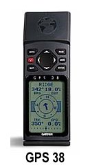 This was the second, after the first drowned on a hard rain ride with the warranty expired. This GPS38 also died from moisture problems but was this time replaced under warranty (Garmins are waterproof — 30 minutes at 1 metre depth, says the manufacturer!).
Current GPS devices
Frequently requested — here is a current summary (as of October 1997):
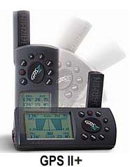
To date I have personally tested or owned the following devices: Sony Pyxis, old Panasonic handheld, Garmin GPS38, GPS40, GPS45, GPS75, GPS12XL (my current one!). The Garmin GPS12XL easily outperforms the old 8-channel multiplex receivers in reception. The new one even keeps working partly inside a garage (open door), in narrow street canyons or under the roof of a petrol station!! The GPS II Plus was placed alongside the GPS12XL (May 1997); it shares the form factor of the GPS II and adds some software features (e.g. selectable icons), plus the same superb 12-channel receiver as the GPS12XL. It costs about 250 US$. Because of the fragile fold-out antenna it is certainly not as robust as the GPS12XL, which I therefore prefer. The GPS12 that appeared in June 1997 looks promising; it differs from the XL variant only in the absence of the antenna socket and the built-in voltage regulator. It is about a quarter cheaper and is certainly a good deal. Completely new on the market in autumn 1997 is the GPS III, which resembles the GPS II Plus in form factor but additionally has a large ROM with integrated moving-map software. It is delivered in 3 versions: with North/Central/South America, or Europe/Africa/Asia/Australia map data, or as a pilot version with worldwide airport data. The price in Germany is said to be just over 1,000 Marks (under 400 dollars in the USA) — rather expensive. The maps are naturally quite coarse, since the device cannot have that much memory (reportedly 4 Mbyte ROM). An improvement is the finer greyscale LCD display (100 × 160 pixels) and the correspondingly improved software, especially in terms of display. The disadvantage is the higher power consumption — batteries drain more than twice as fast as in the GPS II+ or the newer GPS12XL, where they last over 20 hours. Hopefully a vertical version of this device (like the GPS12XL) is also planned; that form factor is actually my preference.
Availability and costs:
The GPS 12XL appeared at the end of February 1997; Därr (Munich, Theresienstr. 66) had obtained a few as the German general importer, but they were immediately sold out; price then 699 Marks (has since become slightly cheaper here). I therefore ordered from the USA, from Larry in Boulder, CO. In March 1997 devices were also extremely scarce there, but he sent me one of the first with the then-current software version 2.0.1. Costs: US$249 plus US$53 for expedited UPS delivery (4-day transit, tracking on the UPS server possible at any time — I eagerly checked every day where my parcel was; the sender must give you the UPS number, mine was 45023523596) plus DM 19.61 customs (declared as "electronic compass", handled by UPS) plus DM 87.51 import VAT (including the bracket also ordered). I can only recommend my dealer in Boulder; he also answers his emails. As I recently learned, he unfortunately no longer ships devices abroad to new customers — he has had bad experiences with being paid. Well worth reading is the GPS 12XL FAQ by Joe Mehaffey and Jack Yeazel, the Garmin gurus.
My GPS III mounted with a self-bent stainless steel bracket on my HPN:
My current Garmin Colorstreetmap mounted with a self-bent stainless steel bracket on my HPN:

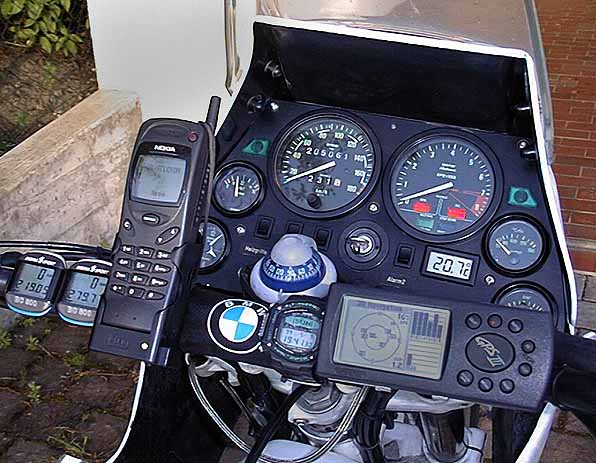
Mounting on the motorcycle:
Tip: The original car bracket for handheld devices can sometimes be used. It is modified and connected to the handlebars via two short M5 soft rubber-mounted studs (available from metal suppliers or as BMW spare parts — Zener diode holder on the Boxer) and two small pipe clamps. This "soft" mounting guarantees survival of the device on rough tracks! Power is taken from the on-board electrics to save the batteries. The Streetpilot is however so large that a self-bent stainless steel bracket is needed. Touratech also offers suitable but rather complicated and expensive brackets that do not look as good; in addition I have routed the antenna under the plastic cockpit to prevent theft or vibrating loose.
Warning: Your GPS will show you exactly where you die!
Therefore always carry map and compass. Never do remote routes alone!
GPS Software
For the Macintosh Larry has a wonderful freeware programme called "larrys-mac-gps" (download). With it you can transfer all position data (768 positions stored in the GPS40, 1024 in the new GPS12XL) to the computer via a serial cable and process them further — e.g. in a spreadsheet. The programme is also available as a Pro version (US$20 by credit card, email the author Larry James); with this it is possible to overlay any scanned map of the recorded route. On the Libya page you will find a link to such a map.
Cool GPS Links — updated 19.Jun.01:
- GPS Nuts
- Joe Mehaffey and Jack Yeazel's GPS Information Website
- The Global Positioning Systems (GPS) Resource Library
- Aviation Formulary — By Ed Williams
- NMEA-0183 and GPS Information by Peter Bennett
- Trimble GPS Tutorial
- GPS Portal: Global Positioning System intro and services
- Global Positioning System Overview
- USCG NAVCEN GPS Technical Reports
- PDF documents to download: -1- -2- -3- -4-
- The Garmin website
- Larry James Software for linking a GARMIN GPS Receiver to a Macintosh
- Build a GPS-to-Computer cable yourself
- The very competent GPS page by Thomas the "Affentwinfahrer" — a must (English)!
- Bernhard Galitzki — GPS Home Page: links on GPS, DGPS services in Germany and abroad, GPS software and GLONASS.
- Cables for use with Garmin GPS Receivers (Larry), well done with photos of the original parts.
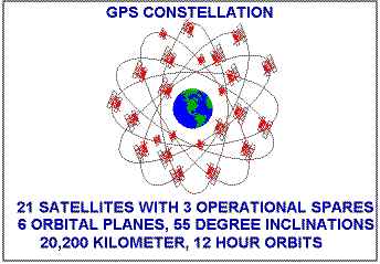
The GPS system
consists of 24 satellites in a medium orbit (approximately half the altitude of geostationary satellites). The satellites' positions therefore change constantly relative to the sky. The GPS receiver calculates the position of the satellites in space based on the high-precision time signal they broadcast (the so-called satellite almanac). A modern GPS receiver can also display this current satellite geometry on screen!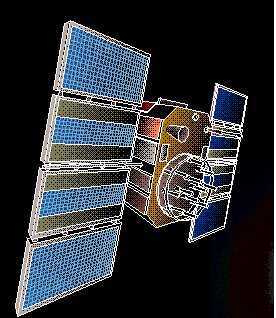
One of the 24 active GPS satellites:
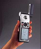
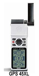
The GPS45 with external antenna (for bikers the GPS38/40 is better):
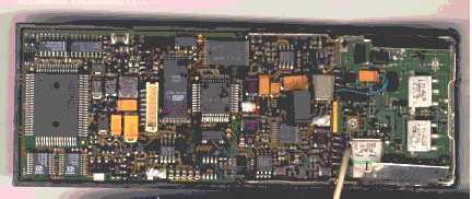
And this is what it looks like inside: